Traveller’s Pocket Companion - British Isles & Ireland

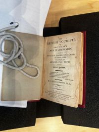
“The British Tourists” or “Traveller's Pocket Companion”[1] is an extensive six volume travel guide of England, Wales, Scotland, and Ireland written by William Mavor in the late eighteenth century. The first volume was published 1798, with the sixth and final volume published in 1800. The guide would likely have been targeted towards affluent individuals from Britain and the rest of Europe who were interested in touring the British Isles. This included people such as aristocrats, wealthy merchants, intellectuals, and adventurers. The guide has significant amounts of information on nearly every region of the British. It served as an effectively accessible instrument of guidance for those who sought to travel by themselves through the region. Its small size allowed the guide to fit in one’s pocket, hence the name, “Pocket Companion.” Today, the Pocket Companion’s great influence and detail are still evident as copies of the same guide are still sold on major websites such as Amazon.com, and Walmart. Original copies of all six volumes were donated by Dr. James Hosmer Penniman as a part of a 3,000 book collection in 1915 to the University of Pennsylvania. These volumes are now found in the Kislak Center for Special Collections at the University of Pennsylvania.
Background and Historical Context
European Tourism in the Late Eighteenth Century
European tourism in the late eighteenth century transformed significantly due to socioeconomic and cultural shifts, namely the Enlightenment. The Enlightenment was defined by a growing urge to explore to increase one’s intellect. This led to a sharp rise in travel across the continent, including Britain. This travel was occasionally referred to as the Grand Tour. It was typically undertaken by young aristocrats and wealthy individuals from nations like Britain and France. Prominent cultural centers such as Paris, Rome, and Venice were some of the most popular destinations to experience art, architecture and literature from different historical periods.[2] While these were the most popular destinations, Great Britain was also a strong point of interest for many. As seen in popular literature from the time such as Mary Shelley’s Frankenstein, many grand tours of Europe eventually made their way to London, and then all the way up to Scotland. The increasing popularity of Grand Tour’s of Europe was made possible by the rapid advancements associated with the Industrial Revolution. As tourism grew around the rise of industrialization, publishers and writers alike sought to capitalize on this by creating extensive guides of destinations. At the time, tour guide books were the only medium other than word of mouth that directly answered people's needs and questions for traveling across the European continent. Copies were published in large amounts due to growing demand, and distributed across population centers. This made it possible for tourists to plan their travel in advance which was a novelty at the time.
Cultural Importance of Travel Guides
Guides provided massive amounts of information about their covered areas. These ranged from first hand experiences, distances from capital cities, routes, accommodations, and even market times and dates of each town in the specified region. This facilitated the planning process as tourists could adjust their itineraries to, for example, arrive in a village on the day of its market to replenish supplies. An additional benefit of this is that it meant tourists could avoid the difficulties of language barriers. Instead of going to great lengths to ask where an inn was located, tourists could travel with confidence to the location. Perhaps the most important, and distinctive features of these early travel guides were the detail in which destinations were described. Contrary to the somewhat dull, and concise descriptions modern guides have, guides such as Mavor’s Pocket Companion, contain eloquent descriptions unique to its author(s). As these guides typically did not have illustrations, it was important that the audience could have a picture in their mind of the destination in question.
Substrate, Format and Binding
Each volume in Mavor’s Pocket Companion is identical when it comes to substrate, format, and binding. The guides were printed using folio folding, meaning that one sheet of paper was folded once to create a recto and verso. The paper used to create the pages of the guides is laid paper, meaning that it was handmade from linen rags. Laid paper is characterized by its chain-like pattern, which is visible when you take a flashlight to any page of the guides. Additionally, the pages are grayish-blue which suggests that perfectly clean white linen rags were not used in the paper-making process. However, there is industrial paper on the flyleaf and pastedown which likely was added later on around the time of donation in the early 20th century. The pastedown has a sticker that denotes the collection it is a part of, and the insignia of the University of Pennsylvania. Each volume is exactly the same size, and is small enough to fit in one’s coat pocket. This explains the choice of title, “Pocket Companion.” This was likely a deliberate choice on behalf of the publishers who wanted to market the guide as something that was easily transportable. The guides are printed and bound, following a folio bibliographic format. In each volume of the collection, the binding is still very much intact which either indicates the quality of binding, or the lack of use over the years.

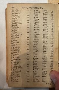
The travel guide has six volumes in total. There is no reference to any of the other volumes in each book. Each volume employs similar navigation tools. There is a table of contents that separates the book into sections, and allows readers to choose which one they would like to use. It simplified the process by which readers could navigate to specific parts of the book using the page numbers, and in turn they could find their desired destination quicker. When traveling, the reader may only be visiting, for example, the Western Islands of Scotland. They would not need the sections on the rest of Scotland, and the table of contents allows them to easily navigate to their desired section of the guide. Another navigational feature is the number of each volume on the spine of each book. Readers could pick out the volume they wanted by identifying the volume number on the spine when taking it out from a bookshelf. The contents of the book are first available on the table of contents. For example, Volume V covers the Isle of Wight, Isle of Man, North and South Wales, and Derbyshire, but this information is only available once you reach the table of contents on the page after the title page. This is different to today as travel guides today will heavily advertise the destination on the cover of the book making it obvious to the reader what place the guide is made for. Finally, there is an index listing cities, and boroughs of the United Kingdom. The index lists the city and/or borough, distance from London, and the market day for each place. This internal book structure is particularly useful for readers of travel guides in the 18th century. Tourists could pick and choose which cities and/or boroughs to go based on their distance from London, and more importantly the day on which their market is held.
Paratexts & Illustrations
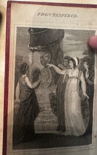
In Volumes I-VI, there is an epigraph from eighteenth century Anglo-Irish poet Oliver Goldsmith’s The Traveller that reads, “My genius spreads her wings, And flies where Britain courts the western spring; Where lawns extend, that scorn Arcadian pride, And brighter streams that fam’d Hydaspis glide.” The quote could be used to inspire the reader to tour Britain due to its natural beauty and cultural richness. The quote highlights the landscapes, and lawns of Britain. It suggests that it is greater than those of Arcadia in Greece, and also the Hydaspis River (modern-day Jhelum River in Pakistan). This adds a certain flair to an already adventurous theme that is continuous throughout the volumes. Unique to Volume 1, is an illustration depiction of four women standing around a statue.

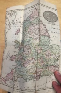
In Volume II, there is a fold-up map before the title page of the book. It only shows England and Wales, but interestingly it is in color. No other book in the six volumes has a map, and there is no color in the rest of the series. This is perhaps the most interesting part of the book as it has many inscriptions on it. There is an X marked on the map on the coast of Cornwall. Additionally, there are more X’s along the coast of Eastern Wales, and the Isle of Man. This suggests that the original owner perhaps planned a trip of the Eastern coast of Britain.

Circulation
These guides have barely been written in, if not at all. The only inscription besides those on the map is a sketch that someone drew on the illustration on the first folio of Volume I. On the statue, there is an engraving of the face of a woman. The lack of marginalia or annotations indicates that the original owner may have taken notes on separate paper, and left the books behind if they did go on a tour of the United Kingdom. Another possibility is that the books were purchased, and simply never used. Their age is still evident when analyzing the books, so it is entirely possible that they sat in a bookshelf for years. Whilst the pages are slightly worn, they are not nearly as worn as other books available for viewing in the University of Pennsylvania’s Kislak Center from the same time period. If the books were used on a tour of the United Kingdom by one party, or more, then we would see more content such as asemic marks, underlining, etc. throughout the volumes, and more general wear and tear to the outside and inside of the books. There would likely be many annotations, and marks left such as from food or dirt.
Readership
William Mavor was an author at the peak of his writing career at the end of the 18th century. Between 1796 and 1800, Mavor had no fewer than ten titles published including his Pocket Companion.[3] Many of his other works also included several volumes including one title that numbered twenty-five volumes. While it is unclear how sizable his readership was, his target audience was certainly clear. Mavor came from a privileged upbringing. In an era of revolutionary fervor, he made his conservative views clear in a story that he wrote called, “The Ocean and The Rivers. A Tale.” In it, he argued that the rivers, or revolutionaries, had no ability to overflow the ocean, or upper class.[4] Taking his position as a high ranking member of the Church, and patron to the Duke of Marlborough, his ability and desire to write the Pocket Companion is understandable. These guides would have proved little use to the lower classes of British society. Travel on this scale would have been nearly impossible to them considering the costs, and time involved in such matters in this time period.
- ↑ Mavor, William Fordyce. The British Tourists: Or, Traveller's Pocket Companion, Through England, Wales, Scotland, and Ireland. Comprehending the Most Celebrated Tours In the British Islands. Second edition. London: Printed by J. Swan, and co., for E. Newbery, 1800.
- ↑ Seaton, A. V. “GRAND TOUR.” Keywords for Travel Writing Studies: A Critical Glossary, edited by Charles Forsdick et al., Anthem Press, 2019, pp. 108–10. JSTOR, https://doi.org/10.2307/j.ctvg5bsp2.41. Accessed 2 May 2024.
- ↑ Dawson, Janis. “Writing for the Young in the Age of Revolution and Reaction: William Fordyce Mavor and ‘The Young Gentleman’s’ and ‘Lady’s Magazine’ (1799-1800).” Victorian Periodicals Review, vol. 34, no. 1, 2001, pp. 16–40. JSTOR, http://www.jstor.org/stable/20083776. Accessed 2 May 2024.
- ↑ Mavor, William Fordyce. Miscellanies, 1829, pp. 35–37.