Scrapbook 1936

The Scrapbook 1936 [1] is called "帝國練習艦隊昭和十一年渡米資料" in Japanese. It's a scrapbook contains materials collected from North and South America.
Overview
The book I investigated is a scrapbook called Teikoku Renshū Kantai Shōwa 11-nen tobei shiryō in Japanese. In English, it means Empire Training Squadron Travel to the United States. The scrapbook is a collection of training manuals, brochures, maps, and postcards collected by a member of the Renshū Kantai on a trip to the United States and Central America in 1936. The earliest-published item in the collection is a Rand-McNally map published in 1923. These items are inserted into a commercially produced "scrapbook" of unidentified manufacture. Some items were inserted in pockets and others were pasted in. The materials are mostly in English and some in Japanese. We saw scrapbook as a genre that became relatively famous as there are similar scrapbooks done by Japanese authors at the time. In the book "Kangei Renshū Kantai norikumi shōshi" [2], this scrapbook collected guidebook to Los Angeles celebrating the arrival of the Japanese training-ships Iwate and Yakumo to the city. we see many visits between Japan and the United States through traveling.
Cover and Binding

The scrapbook has a brown hardcover titled “Scrap Book” on the front and “帝國練習艦隊昭和十一年渡米資料” on the spine. The book is opened from the left and the reader would flip the page from right to left to read through the whole book. Inside the book, the pages are brown as well and relatively thin. They are bound together using an iron structure inside. See Figure to the left. It has some pages left blank while most of the pages have a collection pasted on top of it. Some of the postcards pasted using tape have fallen off and some of the brochures have some minor damages on them which probably happened before being pasted onto this scrapbook.
Content
Geography Variety
The book was made by collecting a wide range of materials from different parts of the US and some even from the South America region like Havana. The collections are very well sorted by geographic location in the book. Materials from different places like Los Angeles, New York, Washington DC, etc. are put together respectively. You will not see a postcard from New York near a map from Los Angeles. The author of this scrapbook has a mental map that helps to filter through the materials and group them together by geographic locations. I would imagine that the author has collected more than needed and all of them are randomly placed initially. The author has put effort into making this scrapbook in organizing materials before it is presented to the reader.
-
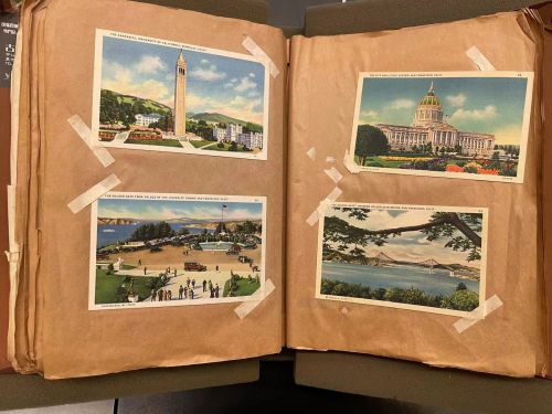
Postcard - Bay Area
-
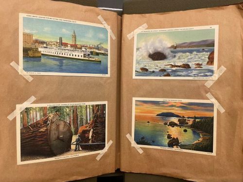
Postcard - Bay Area


-
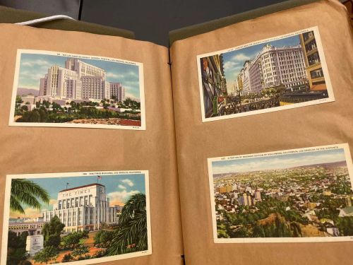
Postcard - Los Angeles
-
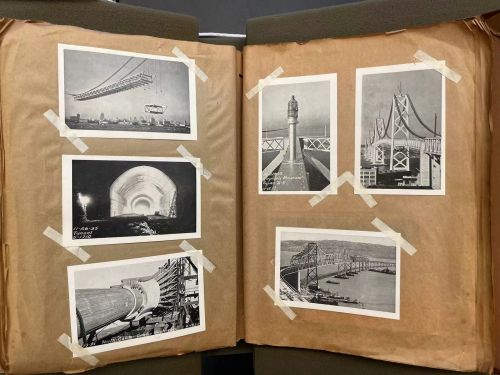
Postcard - Construction


As shown above, we see postcards well organized and grouped together by location. Some of the iconic places in the bay area like the golden state bridge, the city hall, the University of California Berkeley campus, etc. are captured and assembled together. At the right bottom, we see black-white postcards about constructions, bridges, and tunnels which are all related to one another. Some of the postcards are stuck directly onto the scrapbook while others have extra tapes reinforced at the four corners.
Material Variety
Besides the variety of locations, we also see different types of materials being collected. It includes commercial advertisements for cruise trips, tourist maps published by a private company, postcards with beautiful scenery or historical site, booklets with technical explanations of the San Francisco Oakland Bay Bridge, souvenirs from Havana, etc. The selection of materials aims to depict and capture the customs, traditions, and culture of the place. Each of those materials was selected into the book for a reason and the author is trying to show a holistic picture by collecting and selecting delicately.
-
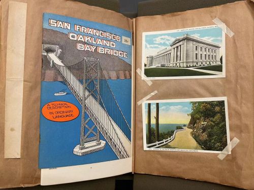
Bay Bridge Cover
-
Content 1
-
Content 2


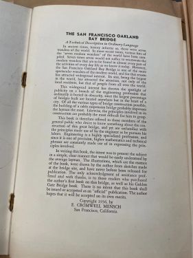
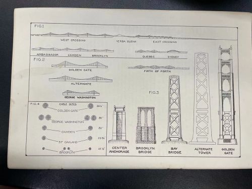
One of the materials being collected that specifically attracts my attention is the brochure about the San Francisco Oakland Bay Bridge shown above. The brochure was made the year that the construction of the bay bridge is completed and was designed as an advertisement for the project. In the introduction, it was written that “In ancient time, history informs us, there were seven wonders of the world. In more recent times, various lists of seven modern wonders have been compiled. … However, the San Francisco Oakland Bay Bridge is one of the more spectacular wonders of the modern world.” We can see how great and magnificent the bridge was at that time and even now. It’s a huge project that connects the two sides of the Bay area that people still use today. I remember driving across the bridge this past winter when I visited the area. I was totally shocked by the view and the construction. You could imagine how surprised and proud people were almost a hundred years ago when it was initially built. The author, likely the architect, who wrote the brochure even compare it with the ancient seven wonders. The right picture shows a graph inside the brochure. The graph details the nuts and bolts of the bridge and how the size is different to serve different purposes. As this is just one of the many examples of deliciated and illustrative graphs in the brochure. It was aimed to educate the general public if not to impress them.
-
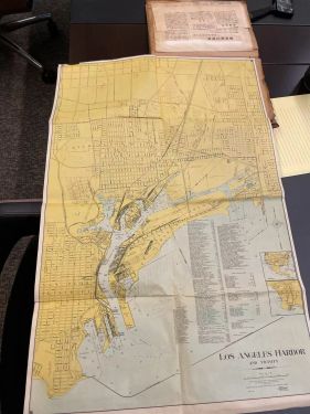
Map of LA
-
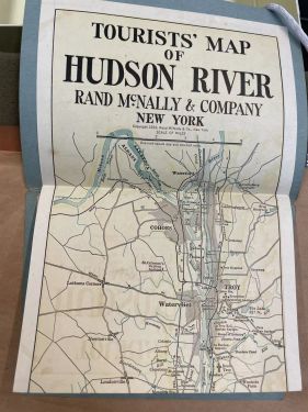
Map of Hudson river


Besides, the scrapbook also collected different maps from different places. As a map is a way of depicting the landscape, it’s interesting to see the difference and similarities of places from then compared to now. On the left, it’s a map of Los Angeles unfolded. It contains details about the harbor and part of the surrounding areas. On the right, it’s a tourist map of the Hudson River. What’s shown in the picture is only one-fifth the length of the whole map. The entire map is laid out vertically and readers can flip through it while taking a cruise on the river. It’s noticeable that most of the maps collected are coastal regions where it’s either a harbor, lake, river, or coastal cities. It’s reasonable to infer that the author took a navel trip around the country and collected maps along the way. Maps especially interest me because it also reflects the culture at the time. According to “What Was a Map? The Lexicographers Reply”[3], the map is defined that is “reflecting changing intellectual fashions
among geographers and, in more recent times, cartographers.” It’s an artifact that is based on fact and tells a lot about what people deemed as fashionable at the time. People at the time might take a cruise on the Hudson River while enjoying the map that tells a holistic story of the landscape.
Language Variety

The variety of languages also contributes to the production of this scrapbook. Since the author is Japanese, he also includes many different materials in Japanese. Although I don’t read Japanese very well, I realize a newspaper written in Japanese published in California that documented the population of Japanese people in South California. The detailed chart contains statistics for males vs. females and people in different age groups. Picture is shown to the right. Again, the author of the scrapbook includes this type of information intentionally and serves the purpose of depicting the culture of the city or state.
The piece that I found especially interesting in the scrapbook was the table that displayed statistics about people of Japanese descent living in San Francisco. Using my deduction skills and understanding of the Chinese language, I am able to guess what the table was describing. When I thought more deeply about the meaning behind the table, I found the meaning of how it represented an understanding of cultural assimilation at the time of its inclusion in the scrapbook. While we often take for granted the amazing cultural heterogeneity of the United States today, the nation's past history regarding immigration and assimilation is checkered with xenophobia, racism, and systematic discrimination. I found it quite heartening that a foreign traveler visiting San Francisco recognized the degree of cultural assimilation of Japanese people, and took it upon themselves to note the associated statistics. I can imagine that this traveler felt quite proud of the fact that their culture was being celebrated and appreciated in an American city, and was excited to share their findings with those back home. This small table illustrates effectively the delicate balance between "Americanization" and preserving cultural heterogeneity, and it really piqued my interest that even travelers passing through San Francisco recognized the great influence that Asian immigrants had on the city, and went past a simple acknowledgment to find and record the associated statistics.
The production
The production of this book is well-planned by the author. Every page is occupied with materials and the layout on each page is well-designed. It’s aesthetically appealing to flip through the book where there is the interplay of picture and text. Postcards are grouped together by geographic location and only the most iconic places are selected for the scrapbook. The author must have collected more than what has been put into the book during traveling. It’s reasonable to infer that there is a selection process where only the best and most representative information will be shown to the reader. In Ellen Garvey’s book “Writing with scissors,”[4] the author talks about the importance of the selection process in the making of a scrape book. Unlike traditional writing where the author uses text to compose, the author uses collected materials to deliver messages in scrapbooks. In Helfand’s book "Scrapbooks: An American History", [5] the author focused on how the scrapbooks tell the history through their origins, their makers, and their diverse forms. For this specific scrapbook, it’s an interesting observation that most of the cities visited are coastal cities. Thus, it’s reasonable to infer the author visited different places through naval traveling. This is also specific to the Japanese culture as they are an island country in East Asia. It's part of the culture that most of the traveling is marine-based. Although the exact process of the production of this valuable scrapbook is unknown, we can make many educated guesses that reveal important information.
Reference
- ↑ https://franklin.library.upenn.edu/catalog/FRANKLIN_9968827463503681
- ↑ Kangei Renshū Kantai Norikumi Shōshi: Iwate, Yakumo Kikō Kinen : July 16-20 1936.
- ↑ Andrews, John. "What was a map? The lexicographers reply." Cartographica: The International Journal for Geographic Information and Geovisualization 33, no. 4 (1996): 1-12.
- ↑ Garvey, Ellen Gruber. Writing with Scissors: American scrapbooks from the Civil War to the Harlem Renaissance. Oxford University Press, 2012.
- ↑ Helfand, Jessica. Scrapbooks: An American History. Yale University Press, 2008.