Maps and Plans Illustrative of Thucydides: Difference between revisions
No edit summary |
No edit summary |
||
| Line 3: | Line 3: | ||
==Joseph Vincent Oxford and Co. Publishing== | ==Joseph Vincent Oxford and Co. Publishing== | ||
Joseph Vincent Oxford, Whittaker and Co., Simpkin and Marshal, and Sherwood, Gilbert, and Piper were a collective of printers and publishers. They worked out of a shop in London during the 19th century. They are responsible for printing over 37 books. The books ranged in content from maps and battle plans about ancient Greece and Rome, questions about important philosophical ideas and literary works, religious works and articles mostly written by the Church of England, translations of ancient texts, chronological cards, and other miscellaneous items.[[File:J. Vincent Oxford 1.png|left|thumb|Part of Catolog of books by J. Vincent Oxford and Co. publishing in "Hints to Freshman in the University of Oxford" by Samuel Reynolds Hole[https://books.google.com/books?id=dLRgAAAAcAAJ&pg=PA37&lpg=PA37&dq=J.+Vincent+Oxford:+Whittaker+and+co.,+Simpkin+and+Marshall,+and+Sherwood,+Gilbert+and+Piper&source=bl&ots=e0stuurBkA&sig=ACfU3U0KQzo3Bekyfo9yjQZhtKEJmWuBsA&hl=en&sa=X&ved=2ahUKEwjp0OWI2P32AhUtZN8KHbdICRAQ6AF6BAgUEAM#v=onepage&q=J.%20Vincent%20Oxford%3A%20Whittaker%20and%20co.%2C%20Simpkin%20and%20Marshall%2C%20and%20Sherwood%2C%20Gilbert%20and%20Piper&f=false]]] The common theme among these books is that they were written for educational purposes, specifically for university students. A catalog of J. Vincent Oxford and Co. books was published in a book titled Hints to Freshman in the University of Oxford written by Samuel Reynolds Hole and published by J. Vincent Oxford.[https://books.google.com/books?id=dLRgAAAAcAAJ&pg=PA37&lpg=PA37&dq=J.+Vincent+Oxford:+Whittaker+and+co.,+Simpkin+and+Marshall,+and+Sherwood,+Gilbert+and+Piper&source=bl&ots=e0stuurBkA&sig=ACfU3U0KQzo3Bekyfo9yjQZhtKEJmWuBsA&hl=en&sa=X&ved=2ahUKEwjp0OWI2P32AhUtZN8KHbdICRAQ6AF6BAgUEAM#v=onepage&q=J.%20Vincent%20Oxford%3A%20Whittaker%20and%20co.%2C%20Simpkin%20and%20Marshall%2C%20and%20Sherwood%2C%20Gilbert%20and%20Piper&f=false | Joseph Vincent Oxford, Whittaker and Co., Simpkin and Marshal, and Sherwood, Gilbert, and Piper were a collective of printers and publishers. They worked out of a shop in London during the 19th century. They are responsible for printing over 37 books. The books ranged in content from maps and battle plans about ancient Greece and Rome, questions about important philosophical ideas and literary works, religious works and articles mostly written by the Church of England, translations of ancient texts, chronological cards, and other miscellaneous items.[[File:J. Vincent Oxford 1.png|left|thumb|Part of Catolog of books by J. Vincent Oxford and Co. publishing in "Hints to Freshman in the University of Oxford" by Samuel Reynolds Hole[https://books.google.com/books?id=dLRgAAAAcAAJ&pg=PA37&lpg=PA37&dq=J.+Vincent+Oxford:+Whittaker+and+co.,+Simpkin+and+Marshall,+and+Sherwood,+Gilbert+and+Piper&source=bl&ots=e0stuurBkA&sig=ACfU3U0KQzo3Bekyfo9yjQZhtKEJmWuBsA&hl=en&sa=X&ved=2ahUKEwjp0OWI2P32AhUtZN8KHbdICRAQ6AF6BAgUEAM#v=onepage&q=J.%20Vincent%20Oxford%3A%20Whittaker%20and%20co.%2C%20Simpkin%20and%20Marshall%2C%20and%20Sherwood%2C%20Gilbert%20and%20Piper&f=false]]] The common theme among these books is that they were written for educational purposes, specifically for university students. A catalog of J. Vincent Oxford and Co. books was published in a book titled Hints to Freshman in the University of Oxford written by Samuel Reynolds Hole and published by J. Vincent Oxford.<ref name="Google"> Reynolds, Samuel. 1843. "Hints To Freshmen In The University Of Oxford. [By S. R. Hole.]". Google Books. https://books.google.com/books?id=dLRgAAAAcAAJ&pg=PA37&lpg=PA37&dq=J.+Vincent+Oxford:+Whittaker+and+co.,+Simpkin+and+Marshall,+and+Sherwood,+Gilbert+and+Piper&source=bl&ots=e0stuurBkA&sig=ACfU3U0KQzo3Bekyfo9yjQZhtKEJmWuBsA&hl=en&sa=X&ved=2ahUKEwjp0OWI2P32AhUtZN8KHbdICRAQ6AF6BAgUEAM#v=onepage&q=J.%20Vincent%20Oxford%3A%20Whittaker%20and%20co.%2C%20Simpkin%20and%20Marshall%2C%20and%20Sherwood%2C%20Gilbert%20and%20Piper&f=false</ref> Samuel Reynolds Hole wrote this book as the Dean of Rochester for the Church of England. Because the catalog was published at the end of this book, it follows that J. Vincent Oxford is trying to advertise his catalog to students. | ||
===Books for Students=== | ===Books for Students=== | ||
This book was designed to teach students about the battles of the Peloponnesian War. It was most likely printed as a visual aid to J. Vincent Oxford’s translation of Thucydides. The book was probably used by students studying history and ancient military tactics. While there is no record of readers, the book was likely passed along by students attempting to save money. | This book was designed to teach students about the battles of the Peloponnesian War. It was most likely printed as a visual aid to J. Vincent Oxford’s translation of Thucydides. The book was probably used by students studying history and ancient military tactics. While there is no record of readers, the book was likely passed along by students attempting to save money. | ||
Revision as of 23:54, 4 May 2022
Overview
Maps and Plans Illustrative of Thucydides is a book containing a collection of intaglio printed maps published by Joseph Vincent Oxford, Whittaker, and Co., Simpkin and Marshal, and Sherwood, Gilbert, and Piper. The book was based on Thucydides’s, the Athenian Historian and General, History of the Peloponnesian War. It currently resides in the Kislak Center for Special Collections and Rare Books and Manuscripts at the Library of the University of Pennsylvania. It is the second edition of the book and was printed approximately in 1832.[4]
Joseph Vincent Oxford and Co. Publishing
Joseph Vincent Oxford, Whittaker and Co., Simpkin and Marshal, and Sherwood, Gilbert, and Piper were a collective of printers and publishers. They worked out of a shop in London during the 19th century. They are responsible for printing over 37 books. The books ranged in content from maps and battle plans about ancient Greece and Rome, questions about important philosophical ideas and literary works, religious works and articles mostly written by the Church of England, translations of ancient texts, chronological cards, and other miscellaneous items.
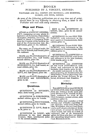
The common theme among these books is that they were written for educational purposes, specifically for university students. A catalog of J. Vincent Oxford and Co. books was published in a book titled Hints to Freshman in the University of Oxford written by Samuel Reynolds Hole and published by J. Vincent Oxford.[1] Samuel Reynolds Hole wrote this book as the Dean of Rochester for the Church of England. Because the catalog was published at the end of this book, it follows that J. Vincent Oxford is trying to advertise his catalog to students.
Books for Students
This book was designed to teach students about the battles of the Peloponnesian War. It was most likely printed as a visual aid to J. Vincent Oxford’s translation of Thucydides. The book was probably used by students studying history and ancient military tactics. While there is no record of readers, the book was likely passed along by students attempting to save money.
Pricing
When Hints to Freshman in the University of Oxford was published in 1843, the price of Maps and Plans Illustrative of Thucydides was 12 shillings. There are 20 shillings in a pound and 1 shilling in 1843 is approximately £6.72. Today, 12 shillings are worth £80.63. An average laborer in 1843 in England made approximately 10 shillings a week. This means that this book was quite expensive for middle and lower-income individuals, which makes sense as university education was typically only for those in the upper class and select individuals from the middle class.
Half Bound
J. Vincent Oxford and Co. used half binding as a cost-saving technique.

A half-bound book is bound by leather on the spine but has cardboard or thick paper on its cover. This saves money because leather was quite expensive in 1832 and J. Vincent Oxford and Co. are selling their book to students who probably would prefer a lower cost. Half-binding most likely increased profitability and the customer base by not pricing individuals out of the market.

Rebinding
The current book in the Kislak Center has been disbound and rebound. The book was rebound by Wert Bookbinding in July 1979.
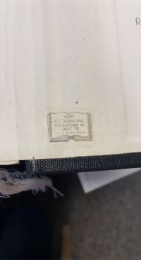
They were hired by the Library of the University of Pennsylvania. It is currently bound in a common library binding from the late 20th century. It was originally in the University library’s circulating collection but was then transferred to the rare book collection within the last 10-15 years according to Dr. John Pollack of the Kislak Center.
Encapsulation
The pages were disbound before being rebound. The pages were professionally removed from the book. When rebound, each page was encapsulated twice. First, each page was covered in a non-plastic film. This film is most likely rice paper. Rice paper protects the paper from wear and tear. The encapsulation provides greater support when the book is read. It ensures that the fragile pages are not harmed through use. It is likely that since the book was originally half-bound, the pages suffered damage from the lack of protection given by the covers.
Linen Backing
Each page is also backed by a layer of cloth. The paper is particularly weak since it is made from cheap paper from the 19th century. Additionally, each map and battle plan is folded in because while the size of the book is octavo, the maps are larger. Due to the time in circulation, tears, specifically in the folds, grew in the paper. The backing adheres to the paper to stay stable and together. The cloth provides an additional layer of protection and support. The strings of cloth have not been cut at the end and hang out of the book. The cloth is soft, lint-free linen.
Intaglio Printing
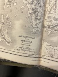
Based on the estimated year of publication, intaglio was the most common technique used to print images, especially in such detail. Each map or plan was engraved on a copper plate. To do so, the engraver uses a burin to draw the images on a flat copper plate. The plate is then layered with ink and wiped down, such that the only ink left is in the grooves. The plate is then put under immense pressure, which causes the paper to suck up the ink. This can be clearly seen in the maps as they are drawn. Notably, the oceans were cleverly drawn as thin lines to create a distinction between the ocean and land.
Thucydides
Thucydides was an Athenian History and General. But, his title did not last long into the Peloponnesian War. After the Amphipolitans surrendered to the Spartan General, Brasidas, the Athenians blamed Thucydides, who was then the Athenian General in Thasos, for the loss, especially as Amphipolis was thought to have great strategic importance. Thucydides then wandered around Peloponnesus, which allowed him to view the war from both sides. During his travels, he wrote a book about the Peloponnesian Wars, History of the Peloponnesian War. His original text was subdivided into 8 books at the Library of Alexandria as hypothesized by scholars. As a neutral party, Thucydides' account is relatively unbiased and contains both stories of historical events and speeches.
Peloponnesian Wars
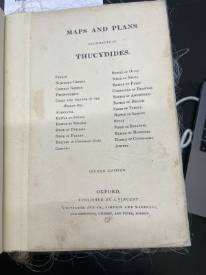
The Peloponnesian Wars were a series of battles fought between Sparta and the Peloponnesian League and Athens and the Delian League. These two groups waged war over a period of 27 years (431 BC - 404 BC). The wars are commonly divided into the First Peloponnesian War and the Second Peloponnesian War. Maps and Plans Illustrative of Thucydides contains engravings from battles throughout the entirety of both these wars. The wars occurred after the Hellenic league, a combination of both sides that defeated the Persians only a decade earlier, disbanded. When the Peloponnesian league withdrew, this raised tensions between the two allies. Many of the battles were fought due to separate circumstances between the different city-states; however, the battles typically included allies from both sides, especially Athens and Sparta.
Thrace
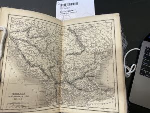
The first map in the book depicts Thrace, where Thucydides was first located as an Athenian General when the wars began. At the time, Thrace was an ally of the Delian League. Located above it is the empire of Macedonia, which was a neutral party during the wars.
Northern Greece
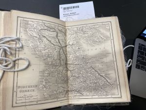
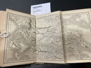
The map of Northern Greece details the geographical and political structures in the region. It includes Attica and Athens as well as Thessae.
Central Greece
Peloponnesus
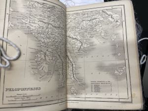
Peloponnesus contains Corinth and Sparta, Laconia. This is where the majority of the Peloponnesian League is located.
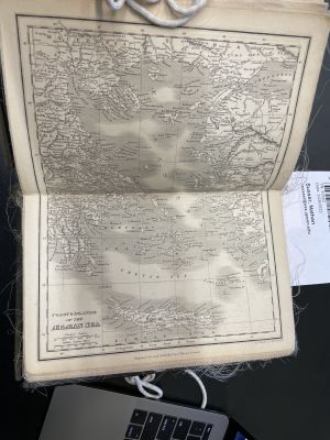
Coast and Islands of the Ægæan Sea
Many of the islands and cities on the coast of the Ægæan were a part of the Delian League.
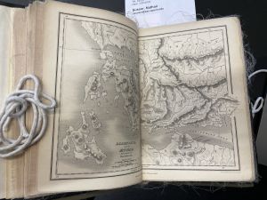
Acarnania and Ætolia
Acarnania and Ætolia is a region located in the SouthWest of Greece.
Battle of Sybota
The Battle of Sybota was fought between the Corcyra, an old Corinthian colony, and the Corinthians. The conflict grew larger when Corcyra, which had the second-largest fleet, allied itself with Athens. The corinthians called upon their Peloponnesian allies to help them. The Corinthians one the first battle against the Corcyreans, but ultimately both sides claimed victory as the Corcyreans avoided an invasion of their city by the Corinthians.
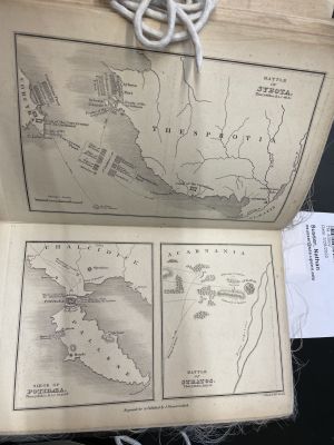
Siege of Potidæa
A catalyst for the war, this battle was fought between the Corinthians and Potidæaens, and the Athenians. Afraid of a revolt by the Delian member, Potidæa, Athens demanded that Potidæa remove its walls and stop accepting Corninthean Magistrates after the Battle of Sybota. This induced the rebellion and Athens sent 30 ships to quell the uprising. Additionally, Macedonia sent cavalry down to help Potidæa, but they ultimately did not get involved in the fight.
Battle of Stratos
The Battle of Stratos was a brief altercation between the Spartans and the Athenians. The Spartans attempted to drive the Athenians out of Acarnania as the Athenian presence threatened members of the Peloponnesian League in the area.
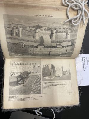
Siege of Platæa
Over two years, the City of Platæa engaged in two confrontations. The first was when 300 Thebans entered the city helped by two citizens. The democratic leadership quickly accepted the Theban's offer of alliance, but after realizing they could overpower the Theban force, slaughtered half of them. Two years later, the Spartans laid siege to the city and burned their fields.
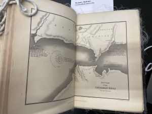
Battles in Crissæan Gulf
These naval battles were fought between the Athenian and Peloponnesian fleets.
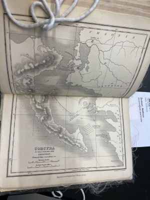
Corcyra
This naval Battle between the Athenian and Peloponnesian fleets involved 12 Athenian vessels confronting 33 Peloponneans ships. An additional 20 Peloponnesian ships came to aid the Peloponnesians while the Athenians dispatched 60 vessels to aid their own troops.
Battle of Olpæ
The Battle of Olpæ was fought on land as Peloponnesian ground forces laid siege to the city of Olpæ. 400 Athenian hoplites came to aid Olpæ and the Athenian fleet also came to defend the city.
Siege of Nisæa
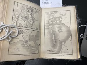
Battle of Pylos
When an Athenian fleet washed up in Pylos, which threatened the Spartans. The Spartans withdrew from a 15-day siege of Attica. The Spartans then attacked the Athenian fortifications where the Athenians were lying in wait. The Athenians destroyed the Spartans and ultimately, the Spartan leadership decided to mediate a temporary truce. Additionally, the Spartans sent a group to Athens to mediate a more permanent peace.
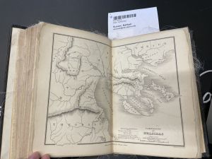
Campaigns of Brasidas
Brasidas, a distinguished Spartan General led a fighting force of 1700 through Thrace, up to Macedonia, and around the Gulf of Torone.
Battle of Delium
The Athenians attempted to set up a base at the temple of Delium. This base was intended to help the Athenians launch an attack on the Bœtians, a Spartan ally. However, the Bœtians attacked the Athenian garrison and defeated them with the help of Thebes.
Siege of Torone
Another battle was waged by Brasidas’ forces against the city of Torone and the port of Lecythus.
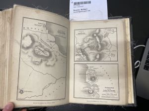
Battle of Lyncus
Lyncestians and Illyrians suffered from Brasidas’ army and the Macedonians.
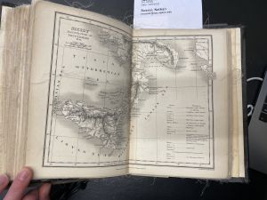
Sicily
This is a map of Sicily, that details the region before presenting the Athenian plan of attack.
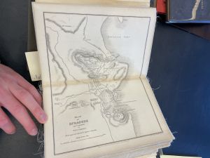
Plan of Syracuse
An Athenian expedition to Sicily ended in a devastating defeat for the Athenians. The book illustrates the Athenians' plan for the battle. However, Syracuse along with help from Sparta and Corinth fought off the Athenian attack and dealt a deadly blow to the Athenian military and navy. This was a crucial loss for Athens that ultimately led to their demise.
Battle of Mantinea
The battle of Mantinea was a land battle fought between Mantineans and their Delian allies and the Thebans and their Peloponnesian allies.
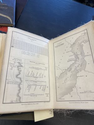
Battle of Cynos-sema
After suffering a defeat in Sicily, the Athenians were facing doom and an end of their democratic governance. In order to ensure their supply lines from the black sea remained intact, the Athenian fleet decided to attack a much larger Spartan fleet. The Athenians narrowly won and the victory gave them momentum to defeat the Spartans twice more in Hellespont.
Athens
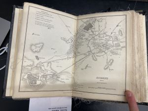
This is a very detailed map of the City of Athens. The walls of the city were crucial in defending against the numerous sieges led by the Spartans, which would cause the populous in Attica to retreat behind the walls. Additionally, the walls enable the Athenians to maintain the critical supply line with the sea where their far-superior naval fleet could dominate the Spartans.
Chronology
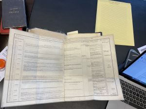
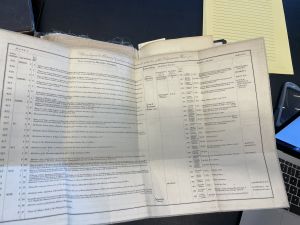
At the end of the book, are two portfolios that contain a chronology of the war. The pages included information from Thucydides as well as other informative sources of the war. It describes major historical events and the history of the rulers of major kingdoms at the time.
Significance
Today, students are able to study a book published for students in 1832. This cycle of learning offers a glimpse into the literary world of education. Students from 1832 onward have used this book to study ancient Greek history. The book remained in circulation for approximately 170 years and must have been analyzed many times during that time period. Now, students can use the book to not only learn about the Peloponnesian wars, but also about the history of books and intaglio printing techniques. If Thucydides was alive today, he would be very proud to know that his book has become a crucial part of history. As he wrote in the introduction, "my work is not a piece of writing designed to meet the taste of an immediate public, but was done to last for ever".
- ↑ Reynolds, Samuel. 1843. "Hints To Freshmen In The University Of Oxford. [By S. R. Hole.]". Google Books. https://books.google.com/books?id=dLRgAAAAcAAJ&pg=PA37&lpg=PA37&dq=J.+Vincent+Oxford:+Whittaker+and+co.,+Simpkin+and+Marshall,+and+Sherwood,+Gilbert+and+Piper&source=bl&ots=e0stuurBkA&sig=ACfU3U0KQzo3Bekyfo9yjQZhtKEJmWuBsA&hl=en&sa=X&ved=2ahUKEwjp0OWI2P32AhUtZN8KHbdICRAQ6AF6BAgUEAM#v=onepage&q=J.%20Vincent%20Oxford%3A%20Whittaker%20and%20co.%2C%20Simpkin%20and%20Marshall%2C%20and%20Sherwood%2C%20Gilbert%20and%20Piper&f=false